Rain-wind analysis
Storyboard 
One of the issues is how rain arrives with the wind at windows and doors. Particularly, if it comes in a perpendicular manner, it creates a zone of low velocity and high pressure. This pressure acts on the windows and doors, causing leaks between them and their frames, promoting water infiltration. Therefore, it is crucial to understand how the wind, and consequently the rain, reaches the windows, either to prevent critical situations or to reinforce them to make them waterproof.
ID:(58, 0)
Access the Application
Description 
To access the application, you have two options:
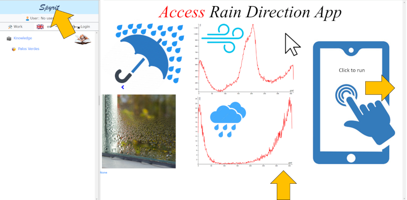
1. Using the images on the right side of the main page:
• Click on the Spyrit logo in the upper-left corner to access the main page.
• Once on the main page, you can browse through the images located on the right side.
• Use the "<" (left) and ">" (right) arrows to navigate between the images.
• When you find the desired image, click on it, and the application will load.
2. Using the navigation menu on the left side:
• Go to the "Knowledge" section in the navigation menu on the left side.
• Then, select "Palos Verdes" from the dropdown menu.
• Next, choose the "Clima" option within the Palos Verdes section.
• Select "Rain" in the submenu.
• Finally, choose "Rain-wind relationship data".
• By following these steps, the application will load.

ID:(474, 0)
Load data
Description 
To be able to access the downloaded data from openweathermap.org (see related presentation), you need to first select the file. To do this, click on the "Load" button and locate the CSV file:
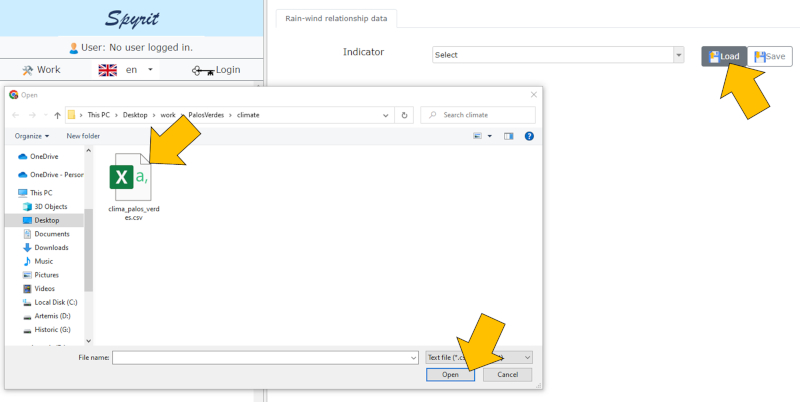
After confirming, the data will be loaded and available for further exploration.
ID:(475, 0)
Average wind speed by direction
Description 
If we observe the average wind speed based on the angle with respect to the north, we can see the following relationship:
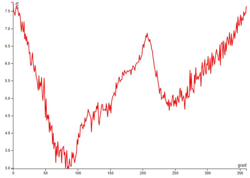
It can be observed that, for this geographical location, the highest wind speeds occur when the wind comes from the south (5.8 m/s) or the north (7.2 m/s). In the west-east direction, the wind is slower, with lower speeds when it comes from the east (3.6 m/s) compared to the west (5.2 m/s). This is mainly due to being located at the foothills of a mountain range that extends from west to east.
If we average the values in different direction ranges, grouping them into 8 categories (N, NE, E, SE, S, SW, W, NW), the following values are obtained:
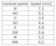
Wind speed is not necessarily associated with rainfall, so it is necessary to study the amount of water fallen by wind direction, which will be presented below.
ID:(476, 0)
Total annual rainfall by direction
Description 
If we observe the rainfall in relation to the wind angle with respect to the north at that moment, we can see the following relationship:
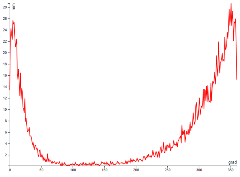
It is clear that there is significant rainfall when there is wind coming from the north. Between the north and northwest wind directions, 74.7% of the rainfall is concentrated. If we calculate an average angle, we find that the rainfall predominantly comes from a direction of -23.9 degrees.
Despite the strong component of south wind, it practically does not bring rainfall, as only 6.4% of the rainfall is recorded between the SE, S, and SW directions.
If we average the values in different direction ranges, grouped into 8 categories (N, NE, E, SE, S, SW, W, NW), we obtain the following values:
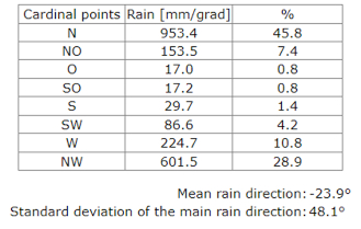
where the dominance of the N and NW directions is clearly recognized.
This behavior can be understood as follows:
• North and northwest winds are masses of air coming from the sea (moist air) that rapidly ascend the hill at a high speed (over 7 m/s). This leads to adiabatic decompression, resulting in cooling and the condensation of water vapor, leading to rainfall.
• South wind comes from a higher area with forests and less humidity, and tends to increase its temperature as it descends towards the sea, favoring the reduction of humidity and, consequently, the absence of condensation.
ID:(477, 0)
Hours of wind by direction
Description 
If we observe the hours in relation to the angle with respect to the north that the wind had at that moment, we can see the following relationship:
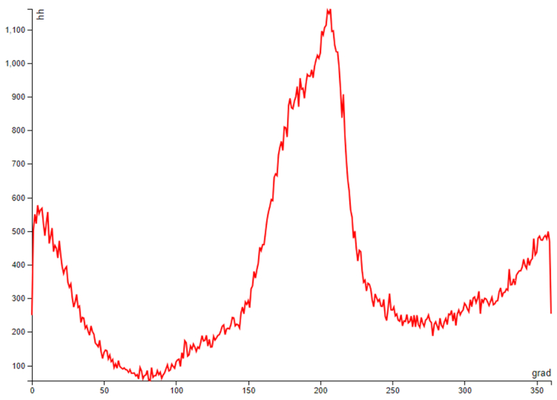
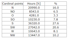
It can be observed that most of the time the wind comes from the south (SE, S, SW), accounting for 56% of the time. If we include the west wind (W), it reaches 64.1% of the time.
The time when it tends to rain is when the wind comes from the north and northwest (N and NW), which represents 26.2% of the time.
If we average the values in different direction ranges, grouped into 8 categories (N, NE, E, SE, S, SW, W, NW), we obtain the following values:
ID:(478, 0)
Rain summary by general directions
Description 
In summary, we have the key values summarized in the following table:
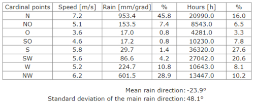
From this, we can conclude that:
• 25% of the time can be expected to have rainfall.
• The rainfall comes from a direction around -24 degrees relative to the north.
• The wind speed is high, with a maximum around 7 m/s.
Therefore, it is important to study the air currents around the house to estimate the pressures that will occur around windows and doors, as leakages may occur.
ID:(479, 0)
Cause of rain with north wind
Description 
To understand the cause of rain under north wind conditions, it is necessary to first understand the location of the plot. It is located about 17 km from Corral, near Chaihuin, in a stretch of coast that runs from east to west:
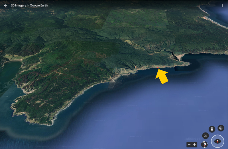
The north-south airflow arrives almost perpendicular to the coast and begins to ascend the hills parallel to the coast. The height of these hills ranges from 100 to 200 meters:
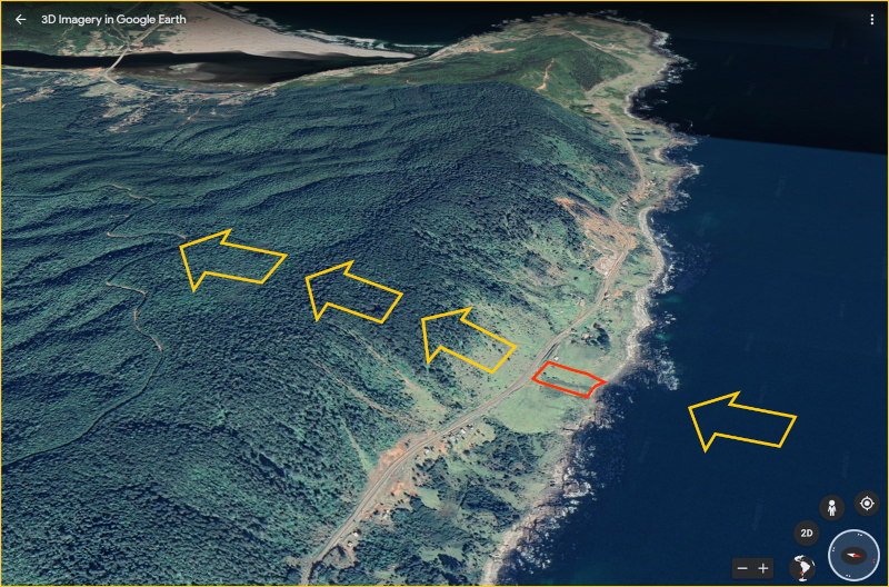
This means that the air, moving at about 7 m/s, along with the humidity from the ocean, ascends relatively quickly, undergoing adiabatic decompression, which leads to a drop in temperature and the condensation of water vapor.
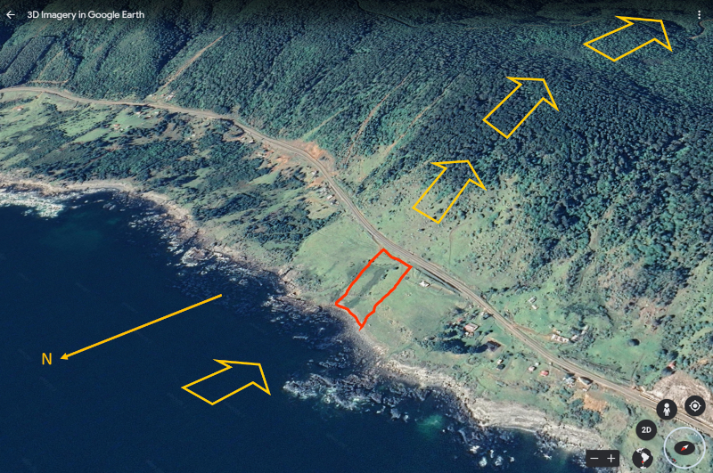
This is why fog forms at the height where vegetation begins, which is where the saturation of ascending air's humidity is reached.
The climatic data represents average values for 5 x 5 km cells, so the rainfall may be lower in some areas. If we observe the vegetation, we can conclude that the rainfall is lower in the lower area of the slope and, therefore, in the location of the house.
When there is a south wind, the air passes over the hills and descends down the slopes towards the sea. As a result, the air has less humidity and tends to compress as it descends the slope, increasing its temperature, which makes condensation and rainfall almost impossible.
ID:(480, 0)
